Projects
I'm interested in all sorts of data-driven science with benefits for humanity and the natural world - especially the challenge of supporting good decisions with data and technology.
I believe that decision systems must be understood and monitored from a bottom-up perspective, giving the beneficiaries of technology a strong voice in its design and ongoing implementation.
Below you can find summaries of my key projects and access my academic papers via public services.
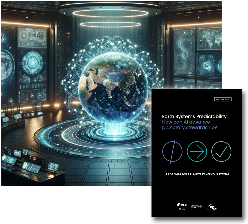
Earth Systems Predictability
Earth Systems Predictability (ESP) is a term that describes how emerging AI and Earth observation technologies can be harnessed to support skilful decision-making that is good for human wellbeing and the long-term health of our planet.
ESP integrates AI-accelerated, data-driven simulations of Earth systems like the climate and biosphere, with human systems like economics and health, via a decision intelligence framework. We propose a distributed system that enables everyone - from shop owners to policy makers - to experiment, learn and make decisions while factoring in long-term impacts on the planet.
The ESP Report synthesises and expands on the outcomes of the ESP Forum: a three-day trans-disciplinary workshop held online in May 2023 in partnership with the ESA 𝝫-Lab, the University of Oxford and Trillium Technologies.
Website: https://trillium.tech/esp
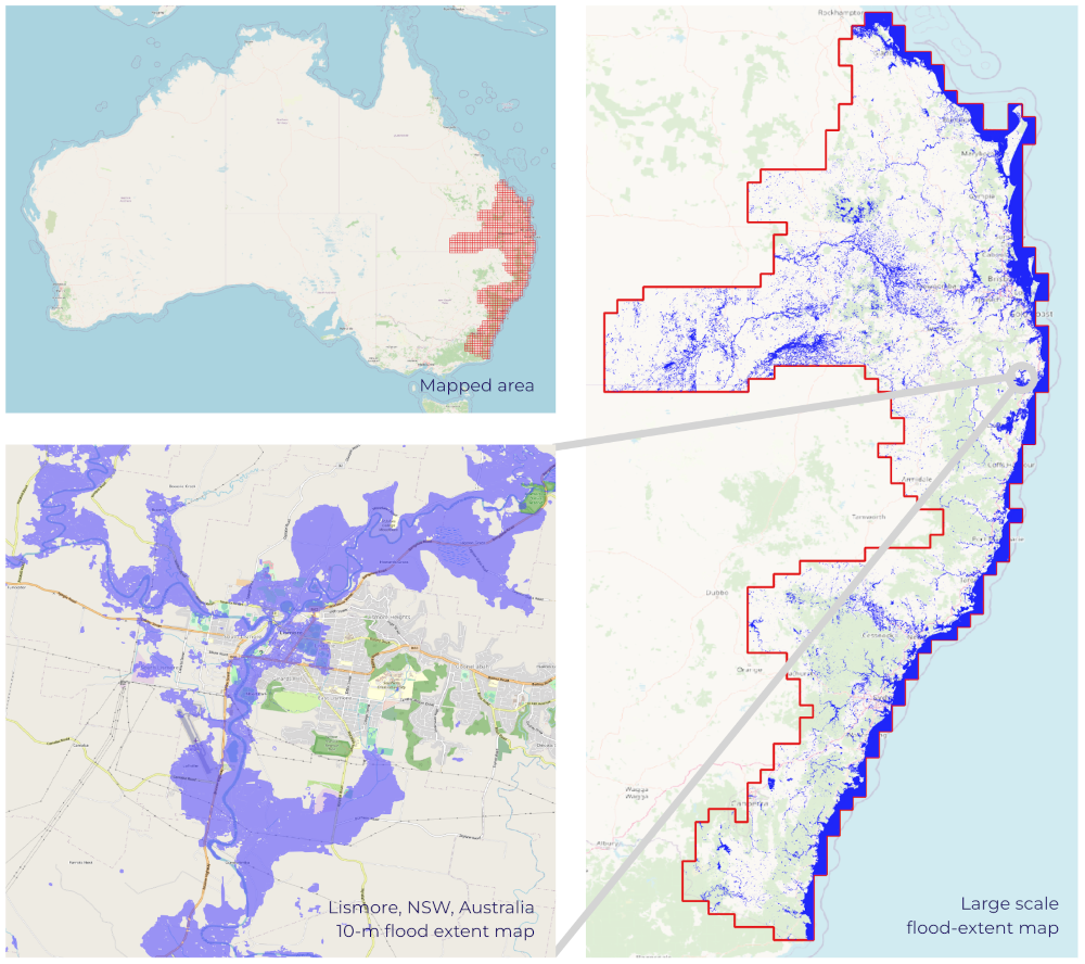
Flood Mapping on Large Scales
Prolonged and heavy rain throughout 2022 gave rise to multiple flooding events in eastern Australia. Trillium's FloodMapper system was one of the few tools capable of mapping the huge extent of the floods on timescales necessary to inform the recovery efforts led by the Australian federal government. The system applies machine learning algorithms to multispectral satellite imagery, quickly generate flood-extent maps at ten metre resolution.
FloodMapper is built using the open ML4Floods toolbox, which was developed during Trillium’s FDL Europe 2019 program and enhanced with the support of the UK Space Agency.
FloodMapper Website: https://trillium.tech/floodmapper
ML4Floods: https://github.com/spaceml-org/ml4floods
Paper: Nature Scientific Reports
Understanding Bushfire Systems
Severe wildfires are becoming increasingly common as a direct result of anthropomorphic climate change. We need to radically improve our fire prevention and management systems worldwide. Artificial intelligence and Earth-observation data can help ameliorate fire risk, detect fires earlier, support live firefighting operations and assist with recovery. However, we need to understand where to concentrate development efforts for maximum impact.
Our team at Trillium Technologies worked with key Australian fire agencies to produce a report on Bushfire Systems and Situational Awareness. The report presents a system-level overview of bushfire management in Australia, with a particular focus on fireground operations. We identify challenges and significant pain points experienced by active firefighters, and show how technology might solve issues in the near future.
Website: https://trillium.tech/bushfires
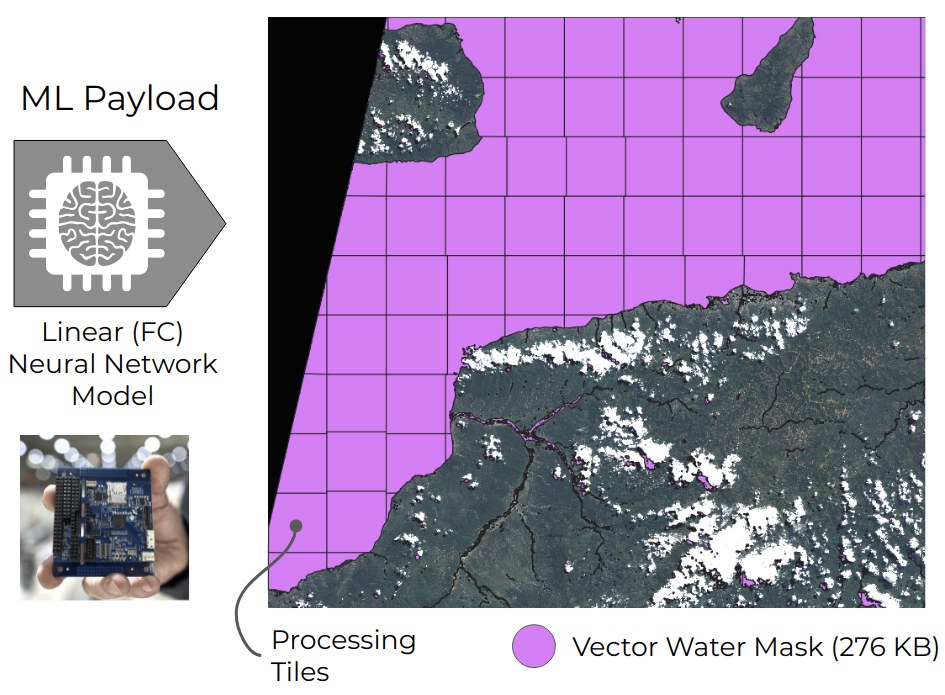
Machine Learning In Orbit
Earth-observation data is extremely powerful for a host of tasks: determining land use, hydrology, measuring flood extent, detecting wildfires - and many more. However, it takes up to 48 hours to download raw data from satellites and process it into a usable form. What if we could move the processing steps onto the satellite (or constellation of satellites) and rapidly download small and insightful data directly to end-users?
Trillium Technologies and FDL, in partnership with ESA 𝝫-Lab, the University of Oxford D-Orbit and Unibap, recently demonstrated the operation of a new Machine Learning (ML) Payload in orbit. Our team engineered the ML Payload to implement the WorldFloods neural network, creating vector-maps of flood extent, sending these to the ground within 15 minutes of image acquisition.
Presentation Video: [YouTube] (5 min)
Press Release: [PDF]
Paper: Nature Scientific Reports
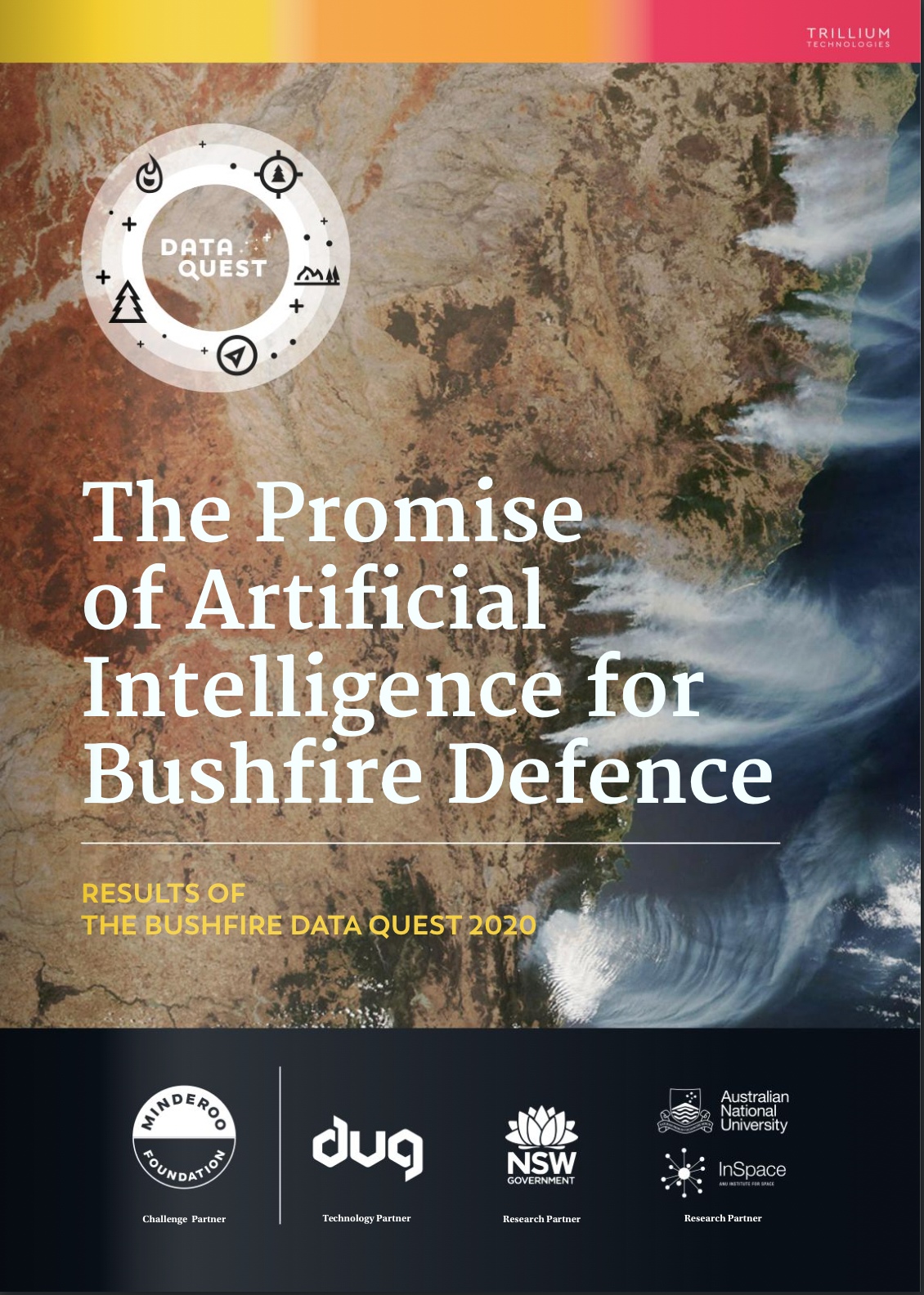
The Bushfire Data Quest
The Bushfire Data Quest 2020 was the first FDL-style accelerated research program in Australia. Frontier Development Lab (FDL) develops solutions to grand challenges by deploying interdisciplinary teams of scientists and AI experts during a focused research 'sprint'. FDL is run in partnership with the major space agencies, Silicon Valley technology companies and world-leading academic groups, who provide expertise to ensure the open science outcomes are excellent.
During the Bushfire Data Quest, the potential of space data and AI for bushfire management was explored across three challenge areas: 1) Fuel and Fire Risk Assessment, 2) Early Detection, and 3) Fire Behaviour. The Data Quest was supported by the NSW Government, the Minderoo Foundation, ANU InSpace and DUG.com as the essential compute provider, in addition to a host of other partners.
Results Document: [PDF] [Calameo]
Website: https://trillium.tech/dataquest2020
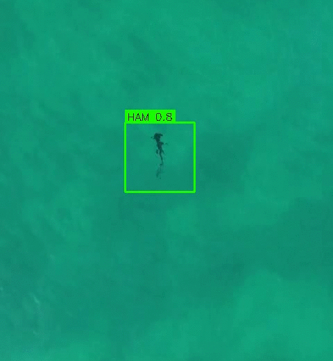
Monitoring Sharks Using Drones
Human-shark conflict, development and climate change present ongoing threats to shark populations in Australian coastal waters. Although rare, shark bites are traumatic events, so the NSW government has made shark management and environmental monitoring a research priority.
Our team from from Sci-eye and the NSW Department of Primary Industries have created intelligent software to detect and identify shark species in live video from shark-spotting drones. The Sharkie App incorporates advanced machine learning techniques and operates on Android mobile devices, without needing an internet connection.
I led the project at Macquarie University with a MQNS Grant and compute support from Fujitsu Australia. Ongoing development by Sci-eye has been supported by funding from the NSW Government.
The Conversation Article: Helping Spot Sharks
Radio Interviews: ABC Newcastle | ABC SE NSW
Fujitsu Blog: Harnessing AI For Ocean Health
Research Paper: Frontiers in Marine Science
Review Paper: The Drone Revolution of Shark Science
The X-Sensing Conference
The 'cross-sensing' conference was established to accelerate interdisciplinary collaboration and promote deep connections between industry and academia. Inspired by the dot-Astronomy conference series, X-Sensing united scientists with industry professionals and experts in artificial intelligence. During the week-long event, astronomers, ecologists, linguists, geographers and medical professionals worked with industry leaders to share knowledge and bootstrap innovative AI-driven projects.
The success of the conference at connecting research and industry inspired Fujitsu's innovative AI Test Drive program.
Website: http://x-sensing.net
Macquarie Drone and Satellite Workshop
Advanced cameras mounted on satellites and unmanned aerial vehicles (UAVs or 'drones') are increasingly being used in diverse fields, ranging from ecology to urban-planning. Multi-spectral satellite data can help monitor the impact of droughts, measure changes in vegetation, or reveal the long-term impact of humans on the landscape. Drones provide complementary, high-resolution and targeted information, and can be cheaply deployed to remote areas at high cadence. In 2019 the Department of Physics and Astronomy at Macquarie University hosted a 1-day workshop on the use of drones and satellite data for research.
Thanks to all presenters for making their slides available on the workshop website.
Website: Workshop Web Page
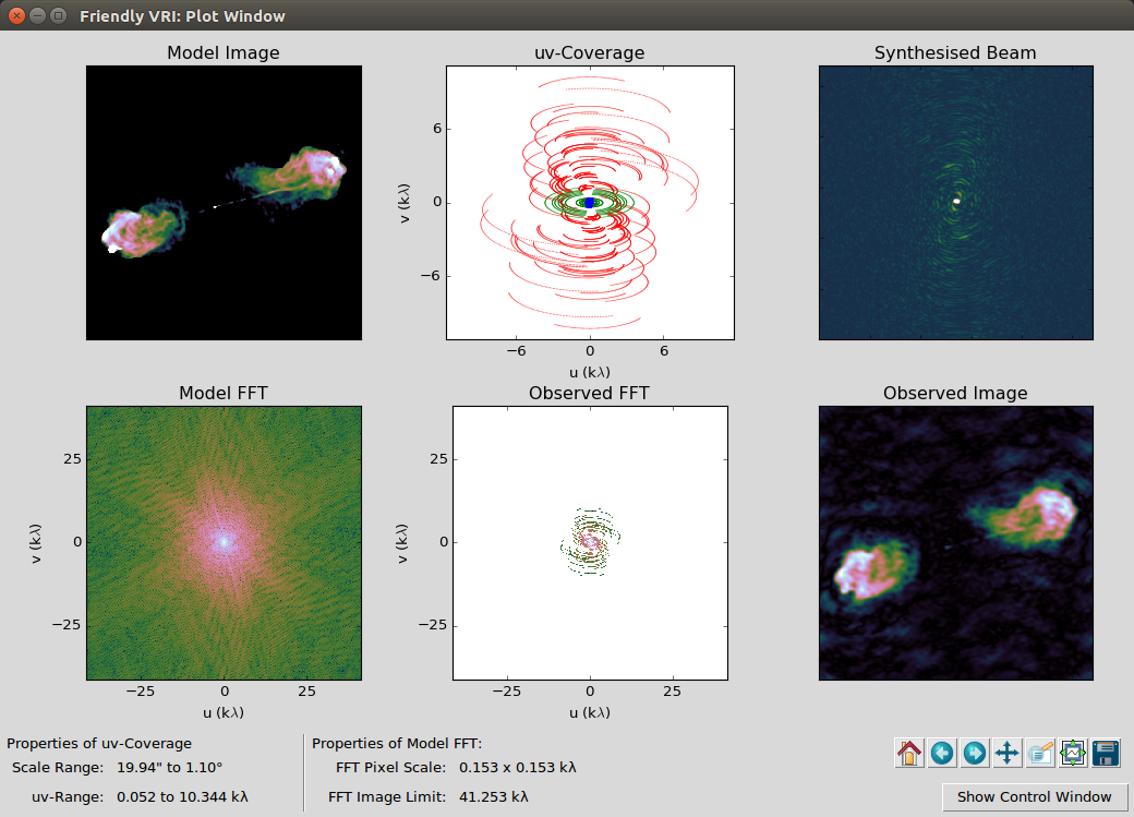
The Friendly Virtual Radio Interferometer
Arrays of radio telescopes are powerful tools for imaging the cosmos as they combine high resolutions with ability to survey large areas of sky. The Friendly Virtual Radio Interferometer (VRI) is software designed to simulate astronomical observations using linked arrays of radio antennas in a technique called Earth rotation aperture synthesis. It focuses on simulating the effect of combining different antenna layouts, helping to build an intuitive understanding of Fourier-domain imaging. Users can select from a wide range of pre-configured arrays (from ALMA, ATCA, GRMT, MeerKAT, PDB, SMA, VLA and WSRT telescopes), or generate their own configurations.
The Friendly VRI can be linked to a bench-top model of a telescope array and has been used around the world as a teaching and outreach tool.
Opening Real Science
The Opening Real Science (ORS) program empowered primary-level educators to confidently teach science and mathematics by providing them with specialised training and support from practising scientists. It was established as a direct response to findings that pre-service teachers in primary schools rarely observed or taught science during their professional experiences.
Our team at Macquarie University co-developed a new curriculum and online modules for use in teacher training programs. We ran professional development workshops for pre-service teachers, embedded astronomers and other scientists in classrooms, and developed a placement program with Sydney Observatory.
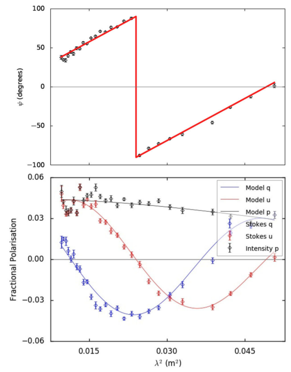
RM-Tools Analysis Software
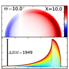
Measurments of magnetism in space rely on the detection of polarised light. At radio wavelengths, Faraday rotation causes the polarisation angle of a linearly polarised electromagnetic wave to be rotated when passing through a magneto-ionic medium. The degree of rotation depends on the wavelength of the emission, meaning multi-wavelength observations can be used to reconstruct the line-of-sight magnetic field.
RM-tools is a software toolkit for deriving Faraday rotation measures, polarised fractions and other related quantities from spectropolarimetric observations on radio telescopes with linearly polarised feeds. The software implements rotation measure synthesis and Stokes QU-fitting to create analysis-ready catalogues of polarised sources.
RM-Tools was initially developed at the University of Sydney, but the toolkit is now part of the Canadian Initiative for Radio Astronomy Data Analysis (CIRADA).
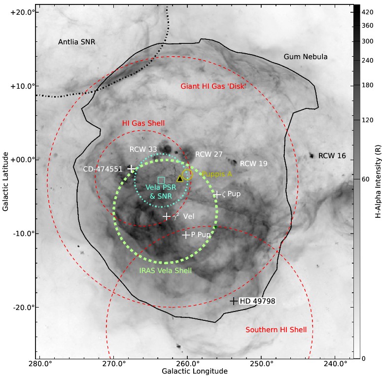
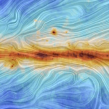
The Gum Nebula and its Environment
The Gum Nebula is 36 degree wide shell-like emission nebula at a distance of only 450 pc. It has been hypothesised to be an old supernova remnant, fossil HII region, wind-blown bubble, or combination of multiple objects. In this project we investigated the magneto-ionic properties of the nebula and its impact on the interstellar medium using data from recent surveys: radio-continuum data from the NRAO VLA and S-band Parkes All Sky Surveys, and H-alpha data from the Southern H-Alpha Sky Survey Atlas.
By analysing rotation measures through the nebula, and by fitting a simple model, we were able to measure the geometry and strength of the local ordered magnetic field. The fitted compression factor at the edge strongly supports the explanation that the nebula is an ionised HII shell around a wind-blown bubble.
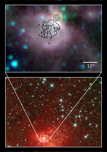
The CORNISH VLA Project
High-mass stars (> 8 M☉) form deep inside giant molecular clouds that block all visible light. These young stars ionise their surroundings, creating bubbles of hydrogen that emit radio waves. Long-wavelength radiation can escape the clouds, so mapping the radio-sky is the best way to answer the fundamental question: How many high-mass stars are there in the Milky Way?
The Co-Ordinated Radio 'N' Infrared Survey for High-mass star formation, or CORNISH, is the radio-continuum counterpart of the mid-infrared Spitzer GLIMPSE project. Observations on the Karl Jansky Very Large Array yielded a high resolution map of the northern Galactic plane at 5 GHz wavelengths - and the most complete census of ultra-compact HII regions to-date.
I led a team from fourteen institutions across the globe to deliver the legacy catalogue and initial scientific results.
Website: http://cornish.leeds.ac.uk
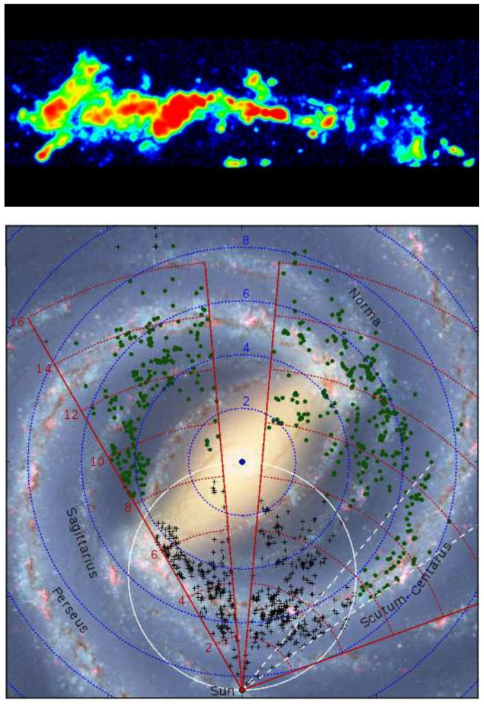
HOPS: a survey of the Galactic Plane
The H2O southern Galactic Plane Survey (HOPS) mapped 100 square degrees of the sky, detecting molecules that emit at wavelengths around 2-cm. Observations on the Mopra telescope targeted a 1-degree wide strip of the Galactic Plane, searching for ammonia and bright water masers. These molecules trace the peaks of giant molecular clouds and regions where gas is violently shocked: the cradles of young stars.
Our observations resulted in a 3-D map showing the distribution and Doppler shift of dense gas in the Galaxy. By matching Doppler shift to Galactic rotational velocity, we created a top-down map of the Milky Way's spiral arms - a highly useful finder chart for future projects investigating star formation.

Triggered Star-formation in NGC 3576
The star-forming region NGC 3576 is a spectacular example of a wave of star-birth sweeping through a giant molecular cloud. At the heart of cloud lies a giant ionised bubble, generated by a cluster of young high-mass stars. Previous observations have shown that the bubble is embedded in clumpy filament of cool dust, prompting the question: Is star-formation being triggered or quenched in the dusty cloud?
To answer this question we used the Australia Telescope Compact Array (ATCA) and Mopra radio telescopes to map NGC 3576 in a suite of molecules: NH3, CO, HCO+, CS, N2H+ and H2O. The resulting maps of temperature and chemistry reveal that star-formation is underway across the whole filament, likely triggered by the expansion of the central bubble.

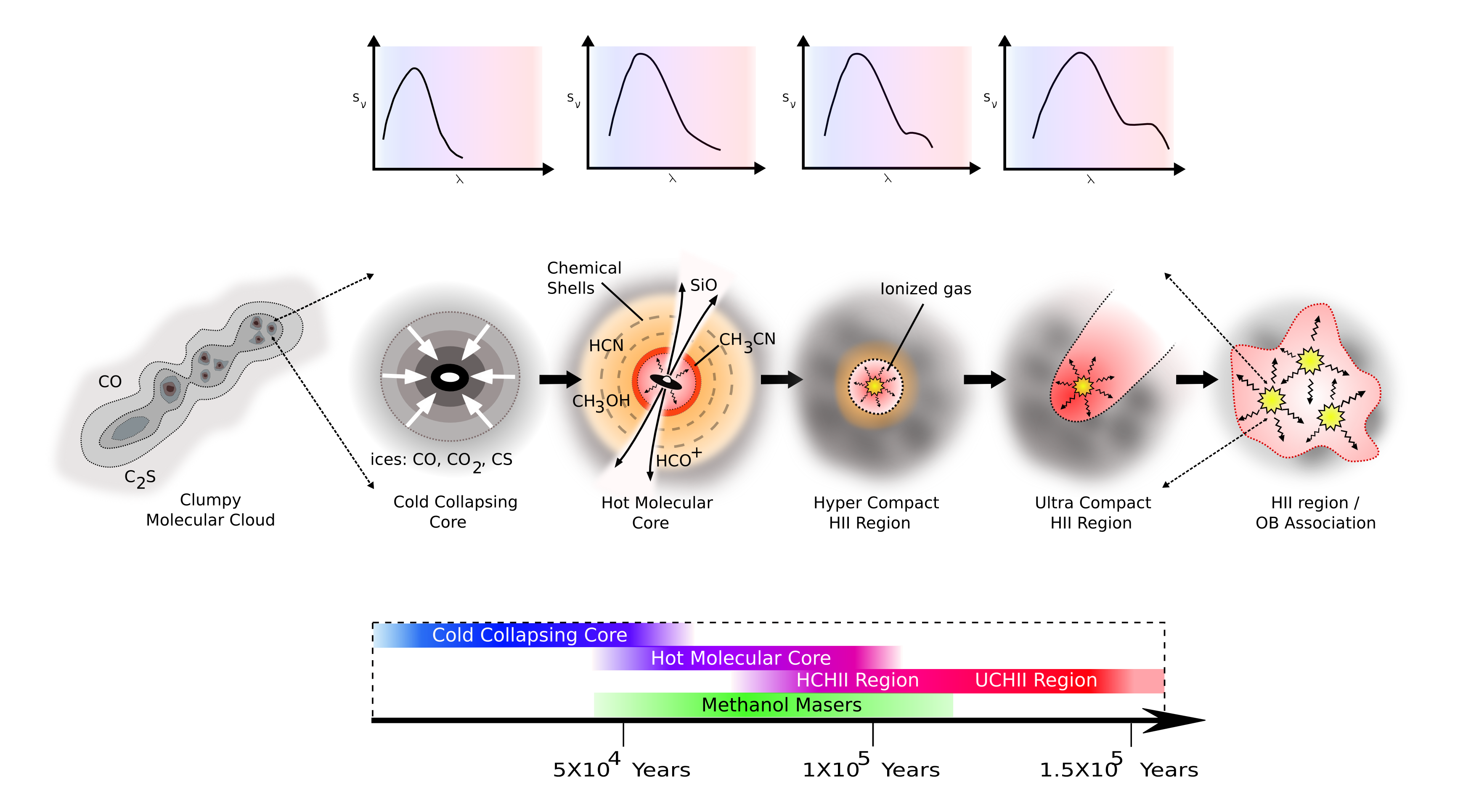
Methanol Masers and Hot Molecular Cores
Stars are formed from collapsing clumps of gas and dust at the heart of giant molecular clouds. This process takes at least 100,000 years, so we can only observe a 'snapshot' of stars forming in the Galaxy. Astronomers study the physics of star-formation by finding many examples with a range of ages and then order them on a timeline.
During my PhD I investigated the 'weather' and chemistry towards methanol masers - signposts to young high-mass stars. Using the Mopra radio telescope I measured the abundance of key organic molecules, proving the link between the early hot molecular core phase of high-mass star-formation and 6.67 GHz CH3OH masers.
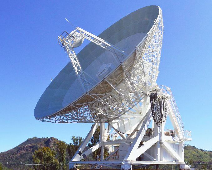
Commissioning the Mopra Telescope
The Mopra Observatory is a 22-m radio-telescope operated by the Australia Telescope National Facility and located at the edge of the Warrumbungle Mountains, near Coonabarabran, NSW, Australia. Radio telescopes like Mopra measure the 'brightness temperature' of gas in their beam (field of view) and make maps by scanning back-and-forth across the sky.
This work to measure the shape of the beam and calibrate the brightness scale paved the way for Mopra to make spectacular 3D-maps of molecular clouds in the southern Galactic Plane: RCW106, Nessie, and many more.
Paper: [ADS]
Astronomy Presentations
These older presentations on astronomy and analysis techniques may be useful to some.

PhD Thesis on Star Formation
My PhD thesis "What's in the Brew? A study of the molecular environment of methanol masers and UCHII regions." was was accepted by the UNSW School of Physics in February 2007. The four main science chapters were published as refereed papers, linked in the projects above.
Thesis Document: [PDF] (14 MB)
LaTeX Code: [Tarball] (21 MB)
Star Formation Sequence Diagram: [PNG] [Tarball: SVG, PDF, PNG]